

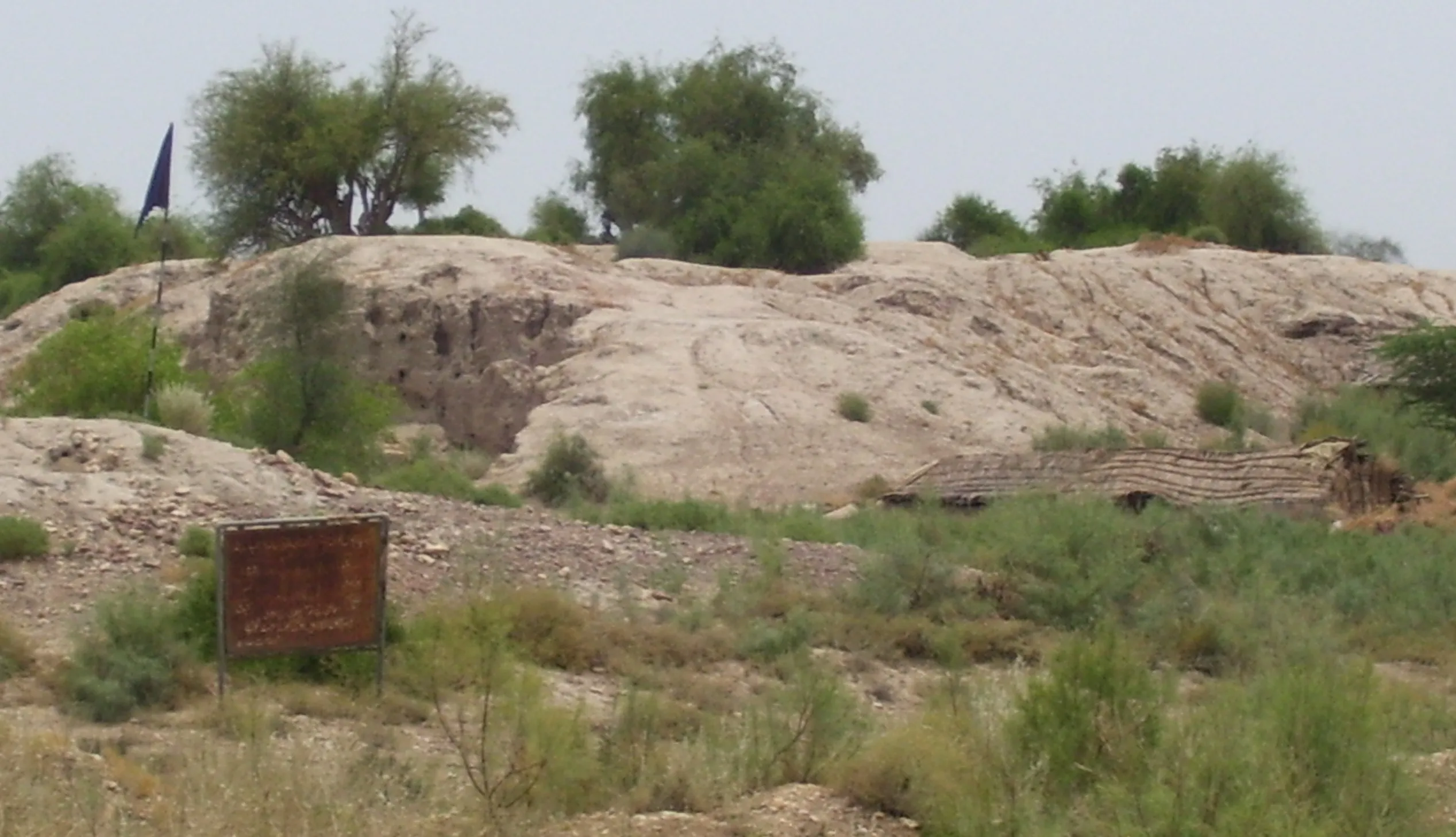
Amri Archaeological Site is an ancient settlement in Sindh, Pakistan, that goes back to 3600 BCE. The site lies on the west bank of the Indus River in Dadu district, south of Mohenjo daro and more than 100 kilometres north of Hyderabad. It is the type site for Amri culture, a local culture that developed in Sindh in the fourth millennium BCE.
In this article (26)
- Where Amri Stands in Sindh Today
- Location on the West Bank of the Indus
- The Mounds and the Shape of the Site
- How Amri Was Found and Recorded
- First Work by N G Majumdar in 1929
- Three Seasons of Work by Jean Marie Casal
- The Five Periods of Life at Amri
- Period One and the Fortified Town
- Period Two and Growing Indus Influence
- Period Three and the Mature Indus Phase
- Period Four and the Jhukar and Jhangar Phases
- Forms, Paint and Decoration in Amri Ware
- Other Objects Made at Amri
- Mud Brick Houses and Small Rooms
- Storage Buildings and Public Spaces
- Food, Animals, Hunting and Fishing
- Farming and Herding at Amri
- Hunting, Fishing and Wild Animals
- Stone, Metal and Distant Materials
- Pottery Styles Shared Across Regions
- Coexistence Rather Than Sudden Replacement
- A Gradual Path Toward Urban Life
- Limits of the Excavated Evidence
- Questions for Future Research
- Amri in the Story of Sindh Today
- Sources
The importance of Amri rests on one clear fact. Here, for the first time, archaeologists found a settlement of pre Harappan date and culture lying under a Harappan one. That layered evidence changed the way scholars think about the growth of towns in the Indus Valley.
The site does not show a sudden break. It shows change over time, with older local traditions living beside newer Indus Valley forms.
This article sets out what is known about Amri from excavation and from the objects found there. It covers the location and the mounds, the history of the digs, the five periods of occupation, the pottery known as Amri Ware, the houses, the food economy and the trade links. It also states plainly where the evidence ends. The aim is to give a reader a reliable account of a site that is central to the early history of Sindh and to the wider story of the Indus Valley Civilisation.
Where Amri Stands in Sindh Today
Amri stands in a landscape shaped by the Indus River and by the hills to the west. The river gave water, fertile soil and a route for movement. The hills gave stone, grazing land and a limit to farming.
Together they set the conditions in which a small town could grow and stay in one place for many centuries. The site is not a large city. It is a compact settlement whose value lies in its long sequence of layers.
Location on the West Bank of the Indus
The Amri Sindh site lies on the Hyderabad Dadu Road, south of Mohenjo daro, in Dadu district. The site is more than 100 kilometres north of Hyderabad and about 160 km south of Mohenjo daro. Its coordinates are 25.90972 N and 67.92361 E. The mounds stand on the west bank of the Indus River, near the foothills of the Kirthar Mountains.
The position is close to a meeting point of regions. Amri is about 10 km from the easternmost extension of the Baluchistan uplands. That short distance matters for archaeology. It put the town within reach of farming communities in Baluchistan to the west and of river settlements in Sindh to the east. The site therefore sat on a route between two zones, and its pottery and other objects show signs of contact in both directions.
The wider setting helps to explain the early farming background of the region. In Baluchistan, farming communities developed from 6000 to 4000 BCE, and that long process ultimately led to urbanisation. Amri belongs to the later part of that story. It was an important earlier urban centre in lower Sindh, close to the source of that farming tradition and close to the river that would support the later cities.
Readers who want the wider context of the river and the hills can start with our guide to the Indus Valley Civilisation history and with our guide to Kirthar National Park. The river and the range frame the whole history of settlement in this part of Sindh, and Amri sits between them.
The Mounds and the Shape of the Site
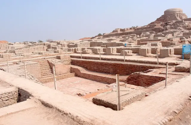
The site covers 8 hectares, which is 20 acres. It has two main mounds, called mound A in the east and mound B in the west. There is also a mound C, northwest of mound B.
Mound A is 44 feet high from plain level. The three mounds together hold the remains of successive towns built on the same ground.

The size is modest when set beside the later cities. Mohenjo daro covers a far larger area, and its streets and drains show a scale of planning that Amri does not have. That contrast is part of the point. Amri had multilevel structures, although it was never a big city. Its interest lies in depth of time rather than in size. The layers allow scholars to follow change in pottery, in houses and in trade over more than two thousand years.
How Amri Was Found and Recorded
The story of Amri as an archaeological site begins in 1929. Before that year, the mounds were known locally, but their age and their place in history had not been shown by excavation. The work that followed, first on a small scale and then in three full seasons, gave the site its place in the record of early Sindh. The published report of that work remains the main source for the site today.
First Work by N G Majumdar in 1929
The archaeological importance of Amri was first demonstrated in 1929 by N G Majumdar. His small scale excavation found, for the first time, a settlement of pre Harappan date and culture that was underlying a Harappan one. That finding was new. Until then, scholars had not seen such a clear case of an earlier local settlement below the later Indus Valley levels at the same site.
Majumdar published only a summary account of his work. The excavation was small, and the record it left was limited. Even so, it pointed to the right question.
If a pre Harappan town lay under a Harappan town at Amri, then the later culture had not appeared from nowhere. It had grown out of, or beside, an older local tradition. That question shaped the later and fuller work at the site.
Three Seasons of Work by Jean Marie Casal
Full work at Amri was done by Jean Marie Casal and colleagues over three seasons from 1959 to 1962. Their excavation established the nature of the pre Harappan culture and the way in which it was replaced. The results were published in the book Fouilles d Amri, Paris, 1964. That book, with its full name meaning excavations at Amri, remains the standard reference for the site.
Casal revealed four successive periods of occupation. The first of these is the Amrian phase, which relates to other pre Harappan sites in the region. Amri is the type site of this early cultural assemblage. In later work, a fifth period, Period V, was added for the Muslim period, dated much later. The four periods found by Casal, plus that later period, form the framework used in this article.
The value of Casal work lies in its care with layers. By digging through the mounds in order, his team could show which pottery, which houses and which objects belonged to each period. That method matters, because it turns a mound of mixed earth into a sequence that can be read.
Without that sequence, the claim that Amri shows gradual change would rest on guesswork. With it, the claim rests on the order in which things were found in the ground.
The Five Periods of Life at Amri
Casal work gave Amri a clear sequence of four periods, with a later fifth period added by later study. The dates are approximate, and scholars may adjust them by a small margin as new work appears. The broad order, however, is settled.
Period One is pre Harappan. Period Two shows growing Indus Valley influence. Period Three belongs almost entirely to the Indus Valley Civilisation.
Period Four shows a mingling of traditions. Period Five is Muslim and much later.
| Period | Dates | Main Features |
|---|---|---|
| Period One | 3600 to 3300 BCE | Fortified town, pre Harappan, Amri Ware pottery |
| Period Two | 2750 to 2450 BCE | Increasing Indus Valley elements beside Amri forms |
| Period Three | 2450 to 1900 BCE | Almost entirely Indus Valley culture, Jhukar subphase at the end |
| Period Four | 1900 to 1300 BCE | Jhukar elements coexist with last Indus Valley phase, later Jhangar ware |
| Period Five | Muslim, much later | Later occupation, not part of the early sequence |
The table gives the framework for the rest of this section. Each period is treated in turn, with attention to what changed and what stayed the same. The aim is not to list dates alone. It is to show how a town lived, worked and changed over more than two thousand years of early history.
Period One and the Fortified Town
Period One ran from 3600 to 3300 BCE. It was a fortified town, and it belonged to the pre Harappan stage of the Indus Valley Civilisation. The earliest phase was a fortified town that flourished in those years. Amri is dated after Rehman Dheri, an earlier site in the northwest. The pottery found in this period had its own characteristics and is known as Amri Ware.
The fortified character of Period One is important. A wall suggests a community that could organise labour, defend its stores and mark its boundary. It does not prove a state or a king.
It does prove a settled town with a shared interest in protection. The houses of this period were of mud brick, and pottery, copper and bronze fragments were also recovered. The town was small, but it was organised.
The wider setting of Period One links Amri to a network of early sites. Amri is the type site for Amri culture, which developed in Sindh during the fourth millennium BCE. The related site of Sohr Damb, also called Nal, lies in Baluchistan to the west of Amri. Their pottery is sometimes described together as Amri Nal ware. The dual type sites are Amri and Sohr Damb Nal, and the culture they name flourished in the fourth and third millennia BCE.
Period Two and Growing Indus Influence
Period Two ran from about 2750 to 2450 BCE. In this period, more and more elements of Indus Valley culture appear. The change is gradual rather than sudden.
Local forms continue, but new forms, new materials and new styles appear beside them. That pattern is the key to Amri. It shows contact and influence, not a simple replacement of one people by another.
The pottery of Period Two shows the same mixed picture. Amri style pottery appears in the Balakot phase, and Kot Diji phase pottery is found at Amri. That two way movement of styles suggests that potters, traders or families were in contact across the region. The presence of similar script characters on the pottery of all these phases suggests that the communication networks linking these phases involved more than just the simple movement of goods.
Kot Diji and Amri are close to each other in Sindh. They earlier developed an indigenous culture which had common elements. Later they came in contact with Harappan culture and fully developed into the mature phase of Indus Valley Civilisation.
That sentence, drawn from the published record, sums up the whole early history of Sindh in a single arc. It moves from local roots, through contact, to a shared mature culture.
Readers can follow the Kot Diji side of that story in our article on Kot Diji Fort in Khairpur. The fort there is much later, from the Talpur period, but the plain below it holds the ancient town that shares its name with the early culture. The two places, Amri and Kot Diji, belong together in any account of pre Harappan Sindh.
Period Three and the Mature Indus Phase
Period Three ran from about 2450 to 1900 BCE. It belongs almost entirely to Indus Valley culture. The evidence from this period gives early, transitional and late smaller phases, running into a final Jhukar subphase.
In plain terms, the town by now looked and worked in the way that scholars associate with the mature Indus Valley. Its pottery, its houses and its objects fit the wider pattern found at larger cities.
That shift does not mean that local life vanished. It means that the forms that had been growing in Period Two now dominate the record. The town was part of a larger world.
Its people used the same kinds of pottery, the same kinds of tools and the same kinds of building methods as people in other Indus Valley towns. The scale was smaller, but the culture was shared. The mature phase is the period when Mohenjo daro flourished, and Amri helps to show how that flourishing was reached.
Evidence indicates widespread fire at the town around 2500 BCE. The cause of that fire is not stated in the sources used here, and this article does not invent one. A fire layer in excavation can mean many things, from an accident to an attack to a deliberate clearing.
What can be said is that the town continued after that date, and that Period Three runs on for several centuries after the fire. The fire is a fact in the ground. Its meaning remains open.
Period Four and the Jhukar and Jhangar Phases
Period Four ran from about 1900 to 1300 BCE. It is marked by the mingling of cultural traditions. Elements of the Jhukar culture appear, and they coexist with the last phase of the Indus Valley culture.
Later, the elements of Jhangar culture appear. The final phase, Period Four, is not well represented in the excavation, but it produced the coarse grey ware comparable to the sites of the Jhangar complex.
The picture in Period Four is therefore one of change and of continuity at the same time. Older Indus Valley forms are still present, but new forms appear beside them. That pattern fits the wider history of the region after 1900 BCE, when the large cities shrank and smaller, more regional cultures continued. Amri does not end with a single event. It fades into a different pattern of life, with new pottery and new connections.
Period Five is Muslim and dated much later. It is not part of the early sequence, and it is noted here only to complete the record. The early story of Amri ends with Period Four. The later occupation shows that the mounds remained a known place long after the early town had passed, but it does not change the reading of the pre Harappan and Harappan periods.
Pottery is the main evidence for Amri culture. It is also the clearest way to follow change through the periods. The shapes, the paint and the decoration change in order, and those changes can be matched to the layers in the mounds.
For that reason, scholars named the whole culture after its pottery. To understand Amri Ware is to understand much of what is known about the site.
Forms, Paint and Decoration in Amri Ware
Amri phase pottery is a red buff ware, mainly handmade. It includes vessel forms such as angular walled and hemispherical bowls, dish on stand, which is rare, and most commonly S shaped jars. The range of forms is practical.
Bowls and jars served for storage, for serving food and for carrying water. The dish on stand is a more formal form, and its rarity suggests a special use.
Black, brown and red paint were applied to the surface of the vessel or to a cream or buff slip in monochrome or bichrome schemes. Decorative schemes emphasised geometric motifs in horizontal bands, with frequent use of checkerboard and sigma motifs. In the later Amri phase, motifs become more complicated and involve the use of intersecting circles, fish scale motifs, zoomorphic motifs and the rare use of red slip. The change from simple bands to complex patterns is a visible sign of growing skill and of wider contact.
The pottery found at Amri had its own characteristics and is known as Amri Ware. That name is not a modern invention for display. It is the term used in the archaeological literature for the red buff ware of the site and of related sites.
The ware is the type fossil of the culture, in the sense that its presence marks the culture in the ground. Where Amri Ware is found, scholars can place a site in the same early tradition.
The craft behind the pottery was skilled work. Ceramic craft specialists were present at Amri, although it is difficult now to establish with certainty other types of full or part time specialists. The presence of specialists means that pottery was not only a household task.
Some people made pots for others, and that division of labour points to a town economy with room for craft. The painted decoration, applied in steady bands, also points to practice and to a shared sense of design.
Other Objects Made at Amri
Other terracotta objects include beads, bangles, humped cattle figurines and circular, square and triangular cakes. The figurines are of special interest. Humped cattle were central to the economy, and their presence in clay suggests that they also held a place in daily thought. The cakes, in three shapes, are less easy to interpret, but their regular forms show that they were made with care and for a purpose.
Stone tools are similar to other phases, except that there was an emphasis on geometric microliths. Those small, shaped stone tools were used for cutting and for working other materials. Only a small number of additional type objects have been identified.
They include carnelian beads, which are rare, shell bangles, bone points and bangles, a steatite rod and a copper blade. Copper and bronze fragments were also recovered.
The list of small finds matters because it shows what was rare and what was common. Pottery and stone tools were common. Carnelian, shell and metal were rare.
That pattern fits a town that was poor in mineral and semi precious stone deposits, yet in contact with groups that could supply such materials. The rare objects are therefore evidence of trade, not of local supply. They show that Amri was not closed in on itself.
Houses at Amri were built of mud brick. That fact, simple as it sounds, tells us about materials, about labour and about daily life. Mud brick was local, cheap and suited to the climate.
Stone was also used in construction, but probably as a foundation for mud brick. The houses were rectangular, and they were divided into small rooms. Their plan changed over time, and those changes can be followed in the excavation report.
Mud Brick Houses and Small Rooms
In Amri IB, several small, contiguous, rectangular mud brick houses divided into small rooms were found. The word contiguous means that the houses stood side by side, sharing walls or touching at the edges. That pattern suggests a compact town, with little waste ground between houses. It also suggests a community that built together, rather than a scatter of separate farmsteads.
Two types of structures were identified in Amri phases IC to ID. One type was a large, rectangular mud brick house with lateral doorways. The other was large rectangular mud brick structures divided into small units similar to those found in the KGM phase at Mehrgarh, which may have had a storage function.
The second type is important because it points to storage on a scale larger than a single household. A town that stores grain or other goods in shared buildings is a town with some form of organisation beyond the family.
The houses were not grand. There is no palace and no large temple in the excavated record at Amri. Public architectural units, such as enclosing walls, have been noted only at unexcavated sites.
That absence is itself evidence. It suggests that power at Amri, if it existed in a formal sense, did not express itself in large public buildings. The town was a place of houses, of work and of storage, rather than a centre of display.
Storage Buildings and Public Spaces
The possible storage buildings at Amri deserve attention. In a farming town, storage is a central problem. Grain must be kept dry, safe from pests and available through the year.
A large building divided into small units fits that need. It allows different households, or a central authority, to keep separate stores under one roof. The comparison with Mehrgarh, where similar structures are found, strengthens the reading. Mehrgarh is an earlier farming site in Baluchistan, and its storage buildings show the same concern with keeping food safe.
The streets and open spaces of Amri are less well known than its houses. Excavation focused on the mounds and on the sequence of layers, and it did not expose a full street plan in the way that work at Mohenjo daro did. What can be said is that the houses were contiguous and rectangular, and that the town was compact.
That compactness, together with the fortified wall of Period One, points to a settled community that valued closeness and defence. For a fuller picture of planned streets and drains, readers can turn to our guide to Mohenjo daro history, where the later city shows those features in full.
The daily life that went on inside those houses can only be guessed from objects. Pots for cooking and storage, beads and bangles for dress, figurines of cattle, stone tools for work, all point to a life centred on the home, the courtyard and the nearby fields. The houses were small, but they held the full range of domestic life. That is the normal pattern for early towns, and Amri fits it.
Food, Animals, Hunting and Fishing
The economy of Amri was based on domesticated plants and animals, especially humped cattle. That base is the same as at other early farming sites in the region. Farming gave grain and other crops.
Herding gave milk, meat, hides and labour. Together they gave the town a stable food supply. The town could therefore support craft workers and traders as well as farmers.
Farming and Herding at Amri
Agriculture, animal husbandry and fishing were the main activities at Amri. The site report lists those three together, and they should be read as a single economy. Fields near the river gave crops.
Herds gave cattle, and cattle gave more than food. Humped cattle appear in the animal bones, in the figurines and in the wider Indus Valley record. They were a central animal, and their presence at Amri ties the town to the farming world of the Indus plain.
The importance of cattle is also shown by the figurines. Terracotta figures of humped cattle are among the small finds at Amri. Such figures may have had a ritual use, or they may have been toys, or they may have served both purposes.
The sources do not settle that question. What they do settle is that cattle mattered enough to be modelled in clay. That is a small but telling piece of evidence for daily values.
Farming at Amri did not stand alone. It was part of a long tradition that began in Baluchistan with farming communities from 6000 to 4000 BCE. Those communities learned to grow crops and to keep animals, and their descendants carried that knowledge into Sindh. Amri is one of the places where that knowledge took town form. The town is therefore a link between the first farming villages and the later cities.
Hunting, Fishing and Wild Animals
Hunting and fishing may have been more important in the Amri phase, though the economy was still based on domesticated plants and animals. That careful wording matters. It does not say that hunting replaced farming.
It says that wild food played a larger part at Amri than at some later sites. The reason may lie in the setting. The river, the marshes and the hills all gave wild food within easy reach.
Some Amri phase sites seem associated with large shell middens, and at Amri, Casal found large quantities of gazelle as well as other wild animals. Shell middens are heaps of shells left after meals, and they show that shellfish were eaten in quantity. Gazelle bones in large numbers show that hunting was regular, not occasional. The picture is of a town that farmed and herded, but that also used the wild resources of its landscape with skill.
A slightly more varied settlement pattern has been noted for the Amri phase. It involves two settlement types, dispersed single or small clusters of houses, and nucleated larger settlements with multiple structures and units of public architecture. This more varied settlement pattern may reflect the larger economic role of hunting and fishing.
A town that hunts and fishes may need smaller outposts near the river or the hills, as well as a central town. Amri itself was the nucleated centre. Smaller sites around it may have been the dispersed part of the same system.

Amri was not an isolated town. Its objects show contact with other groups in the Indus Valley and in Baluchistan. That contact took the form of trade in materials, of shared pottery styles and of shared signs on pottery.
Together those three lines of evidence point to a network that linked Amri to a wider world. The town was small, but its connections were not.
Stone, Metal and Distant Materials
This part of the Indus Valley region is poor in mineral and semi precious stone deposits. The presence of semi precious stones and metal artefacts in the Amri phase therefore indicates some interaction with other social groups in the Indus Valley and in Baluchistan traditions. The logic is simple.
If a material is not found locally, and it is found at the site, then it must have come from elsewhere. The rare carnelian beads, the shell bangles and the copper blade at Amri all fit that logic.
Copper and bronze fragments were also recovered at Amri. Copper was a valuable material in the early Bronze Age, used for tools and for ornaments. Its presence, even in fragments, shows that the town had access to metal.
That access must have come through trade, because copper is not mined in the immediate area. The same point holds for steatite, a soft stone used for seals and for small objects. A steatite rod was found at Amri, and steatite also came from a distance.
The trade in materials was not one way. Amri style pottery is found in the Balakot phase, and Kot Diji phase pottery is found at Amri. That exchange of styles suggests that pots, or potters, moved between sites. It also suggests that the people of Amri had something to offer in return, whether pottery, grain, cattle or other goods.
The exact goods traded are not listed in the sources, and this article does not invent a list. What is clear is that movement went in both directions.
Pottery Styles Shared Across Regions
The sharing of pottery styles is the strongest evidence for contact. Pots are heavy and fragile, so their movement over distance is not trivial. When the same style appears at two sites, it usually means that people, or at least ideas, moved between them.
At Amri, the presence of Kot Diji pottery and the presence of Amri pottery at Balakot show that the early towns of Sindh were in regular contact. They were not separate worlds. They were part of one regional tradition with local variations, and that tradition is the early story of pre Harappan Sindh.
The presence of similar script characters on the pottery of all these phases suggests that the communication networks linking these phases involved more than just the simple movement of goods. That sentence is important, and it should be read with care. It does not say that the script has been read.
No writings were found at Amri, and the Indus script as a whole remains undeciphered. It says that similar signs appear on pottery at different sites, and that such similarity points to shared ideas as well as shared goods.
The wider context for that trade can be followed in our guides to the ancient port of Banbhore and to Manchar Lake. Banbhore is much later, but it shows how the coast and the river served trade in Sindh over a long period. Manchar Lake, west of the Indus in Jamshoro district, shows how water, fish and boat life shaped the same landscape that Amri occupied. The river was always a route, not only a boundary.

Amri matters because it changes a simple story into a more accurate one. The simple story says that the Indus Valley Civilisation appeared suddenly, fully formed, in large planned cities. Amri shows that the story was slower and more mixed. Local towns grew, made contact with each other, shared styles and materials, and only then became part of a larger mature culture. That is a different history, and it is better supported by the ground.
Coexistence Rather Than Sudden Replacement
Based on the evidence from this site, Indus culture was probably not developed directly from Amri culture. Also, at least at this location, rather than suddenly being replaced by the Amri culture, there was a coexistence of both cultures. That reading is drawn from the published record, and it is the central finding of the site.
Coexistence means that two traditions lived side by side in the same town over time. In Period Two, Amri forms and Indus Valley forms appear together. In Period Three, Indus Valley forms dominate, but the change is the result of a long process, not a single event.
In Period Four, Jhukar forms appear beside the last Indus Valley forms. At each stage, the new does not simply erase the old. It joins it, and the mix changes slowly.
That finding challenges the idea of sudden urban development. If cities appeared without local roots, then a site like Amri should show a sharp break, with one culture ending and another beginning at a clear line in the ground. It does not.
It shows a sequence in which local pottery, local houses and local food ways continue while new elements are added. The growth of towns in Sindh was therefore gradual, and it was a synthesis of local and wider traditions.
A Gradual Path Toward Urban Life
The gradual path at Amri fits the wider evidence from Sindh. Kot Diji shows the same pattern, with an early walled town and its own pottery below the Harappan levels. Mohenjo daro shows a later city built on a large scale, with planned streets and drains. The three sites together give a sequence from early town, through contact and growth, to mature city. No single site proves the whole sequence, but together they make a coherent picture.
The significance of Amri is therefore not only local. It is a test case for a theory about how cities grow. The theory that cities grow suddenly, by the arrival of a new people or by a sudden invention, does not fit the layers at Amri.
The theory that cities grow gradually, by the slow joining of local traditions and wider contacts, does fit. That is why scholars return to Amri when they write about the origins of the Indus Valley Civilisation. The site is small, but its lesson is large.
For readers who want to follow that lesson across Sindh, our guide to the Indus Valley Civilisation history places Amri, Kot Diji and Mohenjo daro in one narrative. The fort at Ranikot, in the same Jamshoro district, shows a much later use of the same hills, and it reminds us that the landscape around Amri has been settled and defended for a very long time.

A serious account must state its limits. Amri is well excavated for its period, but the excavation was done more than sixty years ago, and it covered only part of the site. Much remains unknown, and some questions may never be answered from the present evidence. This section sets out the main limits, so that readers do not mistake a careful reading for a complete one.
Limits of the Excavated Evidence
The first limit is the scale of the dig. Majumdar work in 1929 was small, and Casal work in three seasons from 1959 to 1962, though fuller, did not dig the whole site. Public architecture, such as enclosing walls, has been noted only at unexcavated sites.
That means that our picture of public life at Amri rests on a small sample. More digging might change it, but no large new excavation is reported in the sources used here.
The second limit is the absence of writing. Like other pre Harappan towns, no writings were found at Amri. Without writing, we cannot name the town, its rulers or its gods.
We cannot read its own account of itself. We can only read the objects and the layers. That is a real limit, and it applies to the whole early Indus Valley. The script that appears on seals and on pottery at later sites has not been read, and the signs at Amri are even fewer.
The third limit is the state of Period Four. That period is not well represented in the excavation, and its evidence is thin. The coarse grey ware of the Jhangar complex is known, but the houses and the economy of that period are less clear.
The end of the early town is therefore less well known than its beginning. That gap should be kept in mind when reading any account of decline at Amri.
Questions for Future Research
Several questions remain open for future work. One is the exact nature of the storage buildings and of the organisation behind them. Were they shared by the town, or did they belong to a single household or to a temple?
The excavation report notes their form, but it does not settle their use with certainty. A second question is the extent of the dispersed settlements around Amri. If hunting and fishing led to smaller outposts, where were they, and how did they relate to the central town?
A third question is the cause of the fire around 2500 BCE. Was it an accident, an attack or a deliberate act? The layer is there, but the cause is not stated in the sources.
Future research could also use new methods that were not available to Casal. Radiocarbon dating, analysis of animal bones and of plant remains, and study of the clay used in pottery could all add detail. Such work would need fresh excavation or fresh study of the objects already held in museums. Until that work is done, the account in this article should be read as the best reading of the present evidence, not as a final word.
Amri in the Story of Sindh Today
Amri is not a place of grand ruins. It does not have the Great Bath of Mohenjo daro or the long walls of Ranikot. Its mounds are low, its houses were of mud brick, and its pottery is now held in museums and in site stores.
Yet its place in the history of Sindh is secure. It is the site that showed, for the first time, a pre Harappan town under a Harappan one, and it is the type site for a culture that shaped the early history of the region.
The story that Amri tells is a story of gradual growth. Farming communities in Baluchistan learned to grow crops and to keep animals. Their descendants built a fortified town on the west bank of the Indus.
That town made its own painted pottery, built mud brick houses, stored grain, hunted gazelle and fished in the river. It traded for stone and metal that it could not find at home. It shared pottery styles with Kot Diji and with Balakot.
Over time, it took on more and more of the Indus Valley way of life, until it became part of the mature culture that built Mohenjo daro. Then, after 1900 BCE, it changed again, as Jhukar and Jhangar forms appeared beside the last Indus Valley forms.
That story matters for Sindh today because it places the province at the start of one of the great early civilisations of the world. The cities of the Indus Valley did not appear from nowhere. They grew from towns like Amri, in the same landscape, by the same river, under the same hills.
To care for Amri is therefore to care for the beginning of that story. The site is listed by the Sindh heritage record, and the Amri Archaeological Site remains a protected archaeological site. Its future depends on the same care that now protects Mohenjo daro as a World Heritage Site.
Readers who visit Sindh can place Amri in a wider journey. The Indus Valley guide on PakSindh, the Mohenjo daro guide, the Kot Diji guide and the Kirthar National Park guide all belong to the same landscape. Amri is the earliest stop on that journey. It rewards a reader who is willing to look at pottery, at mud brick and at layers in the ground, and to see in them the slow growth of a town, a culture and a civilisation.
Sources
- Wikipedia, Amri Sindh, encyclopaedia entry on the ancient settlement, its periods and its location. Wikipedia Amri page
- Harappa, Amri Pre Harappan Site in Sindh, article on the excavation, the four periods and Amri Ware. Harappa Amri article
- Endowment Fund Trust for Preservation of the Heritage of Sindh, Amri Site in Jamshoro, official heritage record for the site. Sindh heritage Amri record
- UNESCO World Heritage Centre, Archaeological Ruins at Mohenjo daro, World Heritage List entry for the large Indus Valley city north of Amri. UNESCO Mohenjo daro page

Leave a Comment