

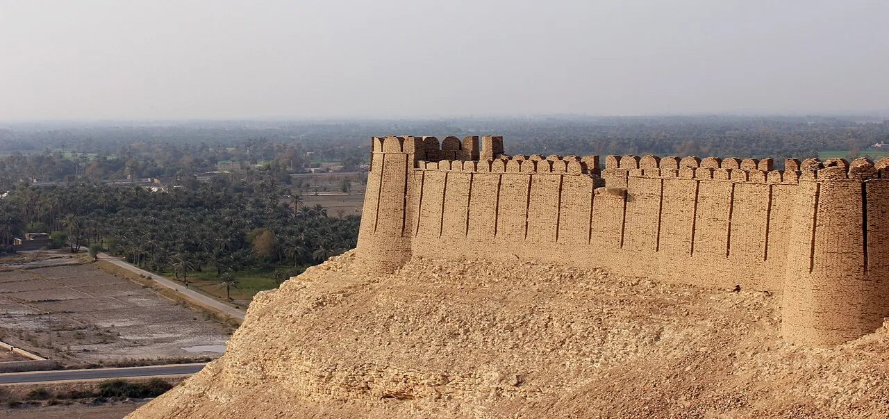
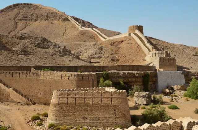
Drive south from Khairpur towards the old National Highway and a long brick wall rises above the flat fields on your right. Its towers sit on a narrow limestone ridge, high above the houses of the town. This is Kot Diji Fort, built by the Talpur Mirs at the end of the eighteenth century and still one of the best preserved forts in Sindh. In March 2026 Pakistan added it to UNESCO’s Tentative List of possible World Heritage Sites.
In this article (13)
- Kot Diji Fort at a glance
- Who built Kot Diji Fort and why
- Where the name comes from
- How the fort was designed for defence
- Three gates on the climb
- Bastions with names
- What to see inside
- From frontier fort to prison and public monument
- A common claim to treat with care
- The older Kot Diji: a town from before the Indus cities
- Visiting Kot Diji Fort
- Why Kot Diji matters
- Sources and further reading
The fort is only half of the story. On the plain just below its walls lies a much older mound, where archaeologists found one of the earliest fortified settlements of the Indus region. Few places in Pakistan let you stand on an eighteenth-century rampart and look down on a town that was occupied almost five thousand years ago. This guide explains what is known about both, and where the popular stories go further than the records.
Kot Diji Fort at a glance
| Location | Kot Diji town, Khairpur District, Sindh. About 25 km from Khairpur city and roughly 400 km from Karachi. |
| Coordinates | approx. 27.345° N, 68.706° E |
| Built | Between 1785 and 1795 (Sindh Antiquities Department). UNESCO’s summary also gives 1797. |
| Builder | Mir Sohrab Khan Talpur, founder of the Khairpur branch of the Talpur family |
| Original name | Qila Ahmadabad (Fort Ahmadabad) |
| Size | Perimeter about 1.8 km on a hill about 110 ft high. Walls about 30 ft high, three main towers about 50 ft high, around 50 bastions. |
| Material | Kiln-baked brick, with stone in some sections |
| Status | Protected monument under the Antiquities Act. In the custody of the Government of Sindh. On UNESCO’s Tentative List since 18 March 2026. |
Who built Kot Diji Fort and why
In 1783 the Talpurs, a Baloch family who had served as commanders under the Kalhora rulers, defeated the Kalhoras at the Battle of Halani and took control of Sindh. They did not rule it as one block. Different branches of the family held different regions. Upper Sindh, around what is now Khairpur, went to Mir Sohrab Khan Talpur. You can read the wider story in our article on the Talpur dynasty.
Mir Sohrab Khan had neighbours to worry about, including the Rajput states of Jodhpur and Jaisalmer to the east and rival claimants within Sindh. According to the Sindh Antiquities Department, he built three forts to guard his frontiers: Shahgarh towards Jodhpur and Jaisalmer, Imamgarh in the Thar desert, and Qila Ahmadabad at Kot Diji, which became his main stronghold. The federal Department of Archaeology’s site record adds that he first set up his headquarters at Kot Diji before Khairpur grew into the capital of the state.
Where the name comes from
The fort’s official name was Ahmadabad. A story repeated in the press holds that it was named after a Persian architect called Ahmed who designed it, and that “Kot Diji” means “fort of the daughter”. Both explanations come from local tradition. We have not found a contemporary document that confirms either, so they are best treated as stories rather than established history.

How the fort was designed for defence
Kot Diji was built as a military post, not as a palace. Its builders chose a long, narrow limestone ridge of the Rohri hills. The federal site record notes that three sides of the hill are almost vertical and that the only practical approach, on the east, is very steep. The walls simply follow the edge of the hilltop. This gives the fort its long, thin shape and means that much of the interior is hard to reach with fire from the plain.
The walls are made of kiln-baked brick. UNESCO’s description gives the standard brick size as about 24 × 11 × 4 cm and says stone was added in places for strength. Burnt brick was chosen because it stands up to cannon fire better than mud brick. Beyond the main fort, an outer mud wall about 5 km long once enclosed the area below the hill.
Three gates on the climb
Visitors still enter the way soldiers did, up a narrow, winding path through three gateways set on different terraces. The narrow approach stopped attackers from bringing large numbers of men, or a battering ram, against a gate at the same time. The outer door is made of thick timber, about 13 ft high and 10 ft wide, and is studded with 234 iron spikes to resist elephants. Sources disagree slightly on the names: the Sindh Antiquities Department calls the third and innermost gate the Shahi Darwazo (Royal Gate), while UNESCO’s summary uses that name for the main entrance.
Bastions with names
The walls are strengthened by around fifty semicircular bastions, which carried cannon and also housed soldiers in their lower levels. Several had their own names. The tower beside the Royal Gate is Fateh Thul, the Victory Tower, from which the commander could watch almost the whole fort. Others are recorded as Saffan Saffa, Mulk Maidan, Mariam Burj, Jaisalmeri Burj and Shaheed Badshah Burj. Machicolations, openings through which defenders could drop stones or hot liquid on attackers, survive along parts of the parapet.

What to see inside
Once past the Royal Gate, the inner fort opens out along the ridge. The most important stores were placed in the centre, where they were hardest to reach.
- Lamp store and food store. Facing the Royal Gate are two roofless rooms. One kept food supplies. The other, with small square niches in its walls, was where clay and glass lamps were cleaned and filled with oil for every part of the fort.
- Ammunition depot. A sunken chamber about 4 m deep, 11 m long and 7 m wide once stored gunpowder and light weapons. Post holes show that it was roofed.
- The pavilion. On the eastern side stands a pavilion of carved sandstone on a raised platform. Its arches rest on columns that UNESCO describes as Corinthian in style. The ruler held court here and issued orders on special occasions.
- The harem. A residence for the ruler’s family has a hall with two side rooms. Its walls carried frescoes and its ceiling was painted with floral designs in lacquer.
- The Mariam cannon. Of the guns that once stood on the bastions, a brass cannon known as Mariam remained in the fort. It carries inscriptions in Persian and Portuguese.
UNESCO’s summary says the fort once held a garrison of about 500 soldiers under a single commander, with around 100 cannon mounted on the walls. Many of those guns were later moved away. In December 2023 the Sindh Culture Department reported that it had traced six cannons that had been missing from Kot Diji for about thirty years, at places including police premises in Khairpur, and had started returning them to the fort.
From frontier fort to prison and public monument
The Talpur state of Hyderabad fell to the British after the Battle of Miani in 1843. The Khairpur branch survived because Mir Ali Murad Talpur had sided with the British, and Khairpur continued as a princely state. With the administration based in Khairpur city, Kot Diji lost its military role. It was turned into a prison, and the Sindh Antiquities Department records that serious offenders from the area and from neighbouring states were held there.
Khairpur joined Pakistan in 1947 and was merged into West Pakistan in 1955. In that year the last ruler, Mir Ali Murad Khan Talpur II, handed the fort over to the government. After the 18th Constitutional Amendment of 2010, responsibility for it passed to the Government of Sindh.
A common claim to treat with care
Many travel posts say that Kot Diji Fort was “never attacked” or “never conquered”. It is true that the official records we consulted describe no siege. But the absence of a recorded battle is not the same as proof that none took place, so we prefer to say simply that no major siege of the fort is documented.
The older Kot Diji: a town from before the Indus cities
At the foot of the ridge is an archaeological mound about 40 ft high and 600 ft long. It was excavated in 1955 and 1957 by Dr Fazal Ahmad Khan of the Pakistan Department of Archaeology. His team found eighteen to twenty layers of occupation.
The upper layers belonged to a small town of the mature Indus (Harappan) civilisation, with stone foundations, mud-brick houses and painted pottery. Beneath them was a thick layer of burnt material, and below that an earlier culture with its own wheel-made pottery, decorated with simple painted bands. That earlier settlement had a defensive wall built on the bedrock, with a stone base about 10 ft high and at least one large rectangular bastion.
This early phase is now called the Kot Dijian culture, an early Harappan stage generally dated to roughly 3300 to 2800 BCE. The name means only that it was first identified here. Similar pottery has since been found at Harappa, Mohenjo-daro and other sites. New excavations at Kot Diji were reported to be under way in 2026.

Visiting Kot Diji Fort
- Getting there: Kot Diji lies on the road between Khairpur and the National Highway. Mohenjo-daro is about 55 km to the west in a straight line. The road journey is longer because it has to cross the Indus, but the two sites still make a good combined trip.
- Best season: November to February. Summer temperatures in upper Sindh can pass 45°C, and there is little shade on the walls.
- Time needed: Allow one and a half to two hours. The climb through the gates is steep, so wear shoes with a good grip.
- Combine it with: Faiz Mahal, the Talpur palace in Khairpur city, and the archaeological mound at the foot of the fort.
- Respect the site: Do not climb on damaged walls or write on the brickwork. The fort is a protected monument.
Why Kot Diji matters
Kot Diji brings two very different chapters of Sindh’s history together in one view. The fort shows how a Talpur ruler of the late eighteenth century used terrain, brick and artillery to protect a new state. The mound below records how people in the same place were building defended towns long before the great Indus cities. With the fort now on UNESCO’s Tentative List, careful conservation and better visitor information can help make sure both chapters survive.
Related on PakSindh: Ranikot Fort, the Great Wall of Sindh and our earlier Roman Urdu article Kot Diji Fort ki tareekh aur pur-asrar qila.
Sources and further reading
- UNESCO World Heritage Centre, “Kot Diji Fort”, Tentative List entry submitted 18 March 2026. whc.unesco.org/en/tentativelists/6968
- Directorate General of Antiquities, Government of Sindh, “Fort of Kotdiji, District Khairpur”. antiquities.sindhculture.gov.pk
- Department of Archaeology and Museums, Government of Pakistan, “Kot Diji Fort” site record. doam.gov.pk
- “Kot Diji Fort needs urgent attention”, Dawn, 21 January 2023. dawn.com/news/1732752
- “Rediscovering heritage: Kot Diji’s missing artillery resurfaces”, The Express Tribune, 6 December 2023. tribune.com.pk
- “Before Mohenjo-daro: New Light on the Beginnings of the Indus Valley Civilisation, from Recent Excavations at Kot Diji”, The Illustrated London News, 24 May 1958, based on notes by Dr F. A. Khan. Reproduced at harappa.com
- F. A. Khan, “Excavations at Kot Diji”, Pakistan Archaeology No. 2, Department of Archaeology, Karachi, 1965.

Leave a Comment