

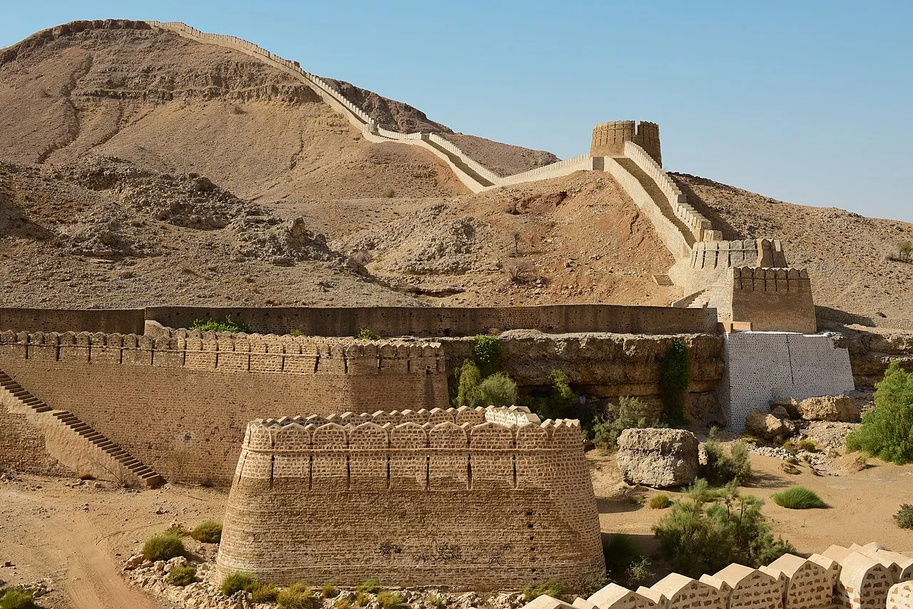
Drive west from the Indus Highway near Sann and the road soon leaves the farmland behind. After about twenty kilometres of dry, broken country, a stone wall appears on the ridgeline. It climbs one hill, drops into a valley and climbs the next. This is Ranikot Fort in Jamshoro District. It is often called the “Great Wall of Sindh”, and it is one of the largest fortified enclosures in the world.
In this article (15)
- Ranikot Fort at a glance
- Where the fort is and how the walls use the hills
- Why the numbers for its size disagree
- Who built Ranikot? The evidence so far
- The Talpur account
- Signs of a much older fort
- What radiocarbon dating says
- Rani or Ranni: the meaning of the name
- The gates of Ranikot
- Miri and Shergarh: the forts inside the fort
- Ranikot in the last days of Talpur rule
- Restoration: mistakes and better practice
- Visiting Ranikot: practical notes
- Why Ranikot matters
- Sources and further reading
Ranikot is also one of the least understood monuments in Pakistan. Nobody knows for certain who first built it, when, or why. This guide brings together what official records, archaeologists and long-time visitors have actually established about the fort. It also points out where the popular story goes beyond the evidence.

Ranikot Fort at a glance
| Location | Lakhi hills of the Kirthar range, Jamshoro District, Sindh (inside Kirthar National Park) |
| Coordinates | approx. 25.896° N, 67.902° E |
| Distance | About 90 km north of Hyderabad. The fort road leaves the Indus Highway near Sann. |
| Size | Perimeter quoted between 26 km and 35 km depending on the source (see below) |
| Material | Dressed limestone and rubble set in lime mortar |
| Main gates | Sann (east), Amri (north), Mohan (west), Shahpar (south), Tori Dhoro (south-east) |
| Inner forts | Miri (Mirikot) and Shergarh |
| Status | Protected under the Antiquities Act 1975. On UNESCO’s Tentative List since 14 December 1993. |
Where the fort is and how the walls use the hills
Ranikot sits on the Lakhi spur of the Kirthar mountains, west of the Indus between Jamshoro and Sehwan. The Endowment Fund Trust for Preservation of the Heritage of Sindh (EFT) has worked at the site since 2014. It describes the fort as lying about 30 km south-west of Sann, on hills whose height varies from roughly 500 to 1,500 feet.
The builders did not wall off the whole valley in one continuous ring. Instead they used the terrain. Where the hills are steep and hard to climb, especially in the north and north-west, there is no rampart at all, only watchtowers. Where the slopes are gentle, masonry walls with rounded bastions close the gaps. The result is a defended valley, not a single building. This is why the figures for the “length” of the fort vary so much.
Why the numbers for its size disagree
If you read about Ranikot, you will find very different measurements:
- UNESCO’s 1993 Tentative List entry gives the fortification wall as 35 km.
- The federal Department of Archaeology and Museums gives a circumference of about 26 km.
- Popular references often quote 31 km.
- The EFT survey gives a periphery of about 32.1 km, of which only about 7.25 km is actual man-made wall. The rest is natural ridgeline.
These figures do not really contradict each other. They measure different things: the full circuit of the defended area, or only the stretches of built wall. When someone calls Ranikot “the largest fort in the world”, they mean the size of the enclosed area, not the length of continuous masonry.

Who built Ranikot? The evidence so far
This is the central mystery of Ranikot, and it is worth separating what is recorded from what is guessed.
The Talpur account
The oldest written explanation comes from the 19th century. A. W. Hughes’s Gazetteer of the Province of Sind (1876) credits the fort to the Talpur Mirs, naming Mir Karam Ali Khan and Mir Murad Ali Khan. Later Sindhi scholarship gives a figure of about 1.2 million rupees for the work. The historian N. A. Baloch, citing the poet Ghulam Ali Ma’il, placed its completion between 1815 and 1819. The Department of Archaeology also records a tradition that Nawab Wali Muhammad Leghari, a minister of the Talpurs, was responsible for building or restoring it.
Signs of a much older fort
Many researchers doubt that the Talpurs built the whole complex from scratch. The travel writer Salman Rashid, who first walked to Ranikot in 1980 and returned many times, made two observations in a 2018 article for Dawn:
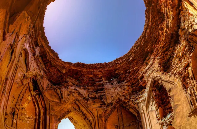
- Where the dressed stone facing has fallen away, several layers of rubble masonry are visible over an earlier clay wall. This suggests repeated rebuilding over a long period.
- In the bed of the stream at Sann Gate, he identified the remains of an old bridge. One collapsed block of masonry has a row of holes for breakwater poles. He argued that a bridge of this kind points to an earlier time with heavier floods and a settlement large enough to need it.
He also recorded 15th-century coins from around the central fort of Miri. These include copies of issues of Sultan Muzaffar of Gujarat and a coin attributed to the Timurid ruler Abu Sa’id Mirza. They show that people were using the site at least as a stopping place on the old route between the coast and Kandahar. Other writers have proposed Parthian, Scythian, Sassanian or even Amri-period origins, but none of these has been proven.
What radiocarbon dating says
The only published scientific date comes from archaeologists Paolo Biagi and Renato Nisbet. In 2009 they collected acacia charcoal trapped in the lime mortar of a collapsed pillar at Sann Gate. The AMS radiocarbon result (160 ± 30 BP) indicates that this pillar was most probably built or repaired between about AD 1720 and 1828, the period of Kalhora and Talpur rule.
This is important but limited evidence. It dates one pillar at one gate, not the entire fort. The authors themselves called for more samples from other parts of the walls. The fairest summary today is this: the Talpurs certainly built or rebuilt large parts of Ranikot in the early 19th century, and there are strong signs of earlier construction underneath.
Rani or Ranni: the meaning of the name
The popular explanation is “Rani Kot”, the Queen’s Fort, but no historical queen is linked to the site. Salman Rashid and several local scholars argue that the name comes from the Ranni stream. This seasonal stream enters the fort near Mohan Gate in the west and leaves through Sann Gate in the east. This is why you will also see the spelling “Rannikot”.
The gates of Ranikot
The EFT lists five entrances:
- Sann Gate (east): the usual entry for visitors coming from the Indus Highway. It is the best-preserved gate, and you can climb onto the walls from it. The Ranni stream exits the fort here.
- Mohan Gate (west): where the stream enters the valley. The ancient route towards Balochistan and Kandahar passed below the western ramparts.
- Amri Gate (north): the northern entrance. It shares its name with Amri, the prehistoric site on the Indus.
- Shahpar Gate (south): on the longest and most striking continuous stretch of wall. According to Rashid, it was originally a gap caused by decay. During the recent restoration it was widened into a proper opening.
- Tori Dhoro (south-east): a smaller entrance mentioned in the EFT survey.
Miri and Shergarh: the forts inside the fort
Ranikot contains two smaller fortresses, each with five bastions according to the EFT.
Miri (Mirikot) stands on a low hill near the centre of the valley, a few kilometres inside Sann Gate. It has a bent, angled entrance that forced attackers to turn and slow down. The remains of living quarters suggest it was used as a residence. UNESCO’s description calls it the probable residence of the ruling Mirs.
Shergarh sits much higher, on a hilltop above Miri, and looks out over a very wide area. Rashid considered Shergarh clearly a Talpur construction, built at the same time that Miri was strengthened.

Ranikot in the last days of Talpur rule
Ranikot appears in historical accounts only briefly. Alexander Burnes, travelling up the Indus in the early 1830s, heard at Sann of a very large fort that had been abandoned because of a shortage of water. He never saw it himself. After the British defeated the Talpurs at Miani and Dubbo in 1843, Mir Sher Muhammad Khan Talpur is said to have retreated to Ranikot for a short time before coming to terms with the British. Shortage of water may also explain why such a large fort never became a permanent city. A garrison could hold the valley, but feeding and watering a large population there would have been difficult.
Restoration: mistakes and better practice
The fort’s recent history shows how restoration can harm a monument as well as save it.
- In the late 1990s, the bridge piers at Sann Gate were given decorative battlements and stairways they never had.
- Further work in the early 2000s used cement and new stone. An enquiry in 2005 found that this broke international conservation standards (the Venice Charter), and the work was stopped in 2006, as Dawn reported at the time.
- From 2014, the EFT took up a new programme. Salman Rashid, visiting in 2018, found the Shahpar wall rebuilt with lime mortar and the original stones. A section of the older layers and the clay core was deliberately left exposed as evidence of the fort’s long history.
For visitors, this means some parts of Ranikot you see today are recent rebuilds. Look closely at the mortar and the stone faces and you can often tell old work from new.
Visiting Ranikot: practical notes
- Getting there: Take the Indus Highway (N-55) from Hyderabad or Jamshoro towards Sehwan. Turn west near Sann. The last stretch to Sann Gate is about 20 km and was a rough road at the time of writing. Check its current condition locally before you go.
- Season: November to February is the most comfortable time. Summer temperatures in the Kirthar hills are extreme, and there is very little shade.
- Water and food: Carry your own. Facilities inside the fort are basic and not always open.
- Time: A visit to Sann Gate, Miri and a section of wall needs at least half a day. Walking to Shergarh and Shahpar takes longer.
- Respect the site: Do not climb on loose masonry, remove stones or scratch names on the walls. Ranikot is a protected monument under the Antiquities Act.
Why Ranikot matters
Ranikot is not just a big wall. It shows how the people of Sindh used the Kirthar hills for defence. It also records more than one period of building, possibly over many centuries, and gives a rare view of how the Talpur Mirs tried to protect their state in its final decades. More scientific dating and careful conservation could answer many of the questions that remain. Until then, honest guides should present Ranikot as what it is: an impressive monument whose full story has not yet been written.
Read our earlier Roman Urdu article: Ranikot ki mukammal tareekh. Related on PakSindh: the Talpur dynasty and Kot Diji Fort.
Sources and further reading
- UNESCO World Heritage Centre, “Rani Kot Fort, Dadu”, Tentative List entry submitted 14 December 1993. whc.unesco.org/en/tentativelists/1284
- Department of Archaeology and Museums, Government of Pakistan, “Ranikot Fort” site record (citing Inventory of Cultural Property in the Province of Sindh, 2015). doam.gov.pk
- Endowment Fund Trust for Preservation of the Heritage of Sindh, “Ranikot” project page. eftsindh.org.pk
- Paolo Biagi and Renato Nisbet, “Ranikot Fort (Jamshoro, Sindh): An AMS Radiocarbon Date from Sann (Eastern) Gate”, Journal of Asian Civilizations 32(2), 2009. PDF via harappa.com
- Salman Rashid, “Archaeology: The enigma of Rannikot”, Dawn (EOS), 15 April 2018. dawn.com/news/1401651
- A. W. Hughes, A Gazetteer of the Province of Sind, London: George Bell and Sons, 1876.
- N. A. Baloch, Sindh: Studies Historical, Pakistan Study Centre, University of Sindh, 2002.
- Badar Abro, Ranikot: The Wall of Sindh, Endowment Fund Trust, 2019.

Leave a Comment