

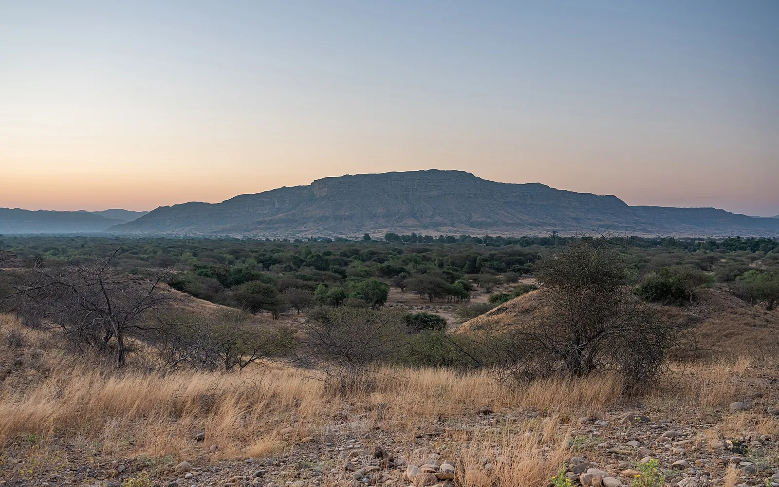
If I had said that there was a place within Karachi where you could escape all the skyscrapers, busyness and traffic and find quite the opposite with peaceful hills, rocky terrain, open fields and endless natural views, you would probably not believe me. However, Mehar Jabal Karachi is one of these places!
In this article (20)
- Mehar Jabal at a Glance
- Where Is Mehar Jabal?
- How to Get to Mehar Jabal Karachi
- The Hilly Terrain and Wildlife of Gadap Town
- Hilly Adventures at Mehar Jabal
- Camping and Stargazing
- Population of Mehar Jabal
- Photography and Tourism in Karachi
- Best Time to Visit Mehar Jabal
- Safety Tips for Visiting Mehar Jabal
- Mehar Jabal Karachi FAQs
- Where is Mehar Jabal in Karachi?
- How many people live in Mehar Jabal?
- Is Mehar Jabal safe to visit?
- When is the best time to go?
- Can you see wildlife at Mehar Jabal?
- How high is Mehar Jabal?
- Can you camp at Mehar Jabal?
- Why Visit Mehar Jabal?
- Sources and Further Reading
Mehar Jabal is in Gadap Town and its name is in the official deh list of the Sindh Board of Revenue. So it isn’t just a name that went viral on social media. It has a real place in local land records too.
Mehar Jabal at a Glance
Quick facts first, for anyone planning a trip:
- Where: Gadap, Malir District, Karachi. Mapping data puts the hill at about 25.53° N, 67.32° E, near Goth Waro and Goth Jabal.
- Height: roughly 464 metres (about 1,520 feet) above sea level.
- Size of the top: a flat plateau that travellers describe as around 10 km long and 4 km wide.
- Distance: about 100 km from central Karachi, on a mix of paved road and dirt track.
- People: 819 residents in the 2023 Census.
- Best time: November to February.
- Facilities: almost none. No restaurants or shops on top, so bring everything with you.
Where Is Mehar Jabal?
Mehar Jabal is shown on maps as a hill in Malir District, at a height of about 464 metres. Not much, you might think. But most of Karachi is barely above sea level, so you really do feel the climb. The nearest settlements are small goths such as Goth Waro and Goth Jabal.
Gadap is enormous. It is the biggest town in Karachi by area and covers more than 1,100 square kilometres between the Hub River and the Kirthar hills. Despite its size, the whole Gadap sub-division had only around 100,000 people in the 2023 Census, so most of it is still empty, rural land.
Gadap Town is part of Malir within Karachi Division. There are several dehs in Gadap, and the revenue records list Mehar Jabal as one of them.

How to Get to Mehar Jabal Karachi
You can start the journey to Mehar Jabal from PECHS. As you head out of the centre of the city, you will notice the landscape start to change. You will move away from the busy roads and bustling areas of Karachi to find open lands, small towns, dry terrain, shrubs and hilly ranges. This is a side of Karachi that often gets overlooked!
Long drive ahead. A trip report from 2018 puts Mehar Jabal roughly 100 km from Karachi, with a tarmac road for part of the way and then a dirt track. Google Maps may mark the site as Goth Sukhio, so confirm the pin before setting off and download an offline map, as there may be no signal out there.

The Hilly Terrain and Wildlife of Gadap Town
As you drive to Mehar Jabal, you will notice the terrain of the road changing throughout the journey. There will be flat terrain and then soon rocky paths and hill climbs. The small hills will appear quite large once you are up close!
This area is special because it has quite a dry and rocky terrain. There isn’t much water or greenery, but that doesn’t mean there’s no life here. There are still small shrubs and hardy plants within this area that are an important part of the local ecosystem. They can provide food and shelter for a variety of animals.

There is also some interesting wildlife information regarding this area. An old zoological survey looked at wild animals in the hilly areas of Sindh and recorded urial (known locally as gud) at Mehar Jabal. This was published in the Pakistan Journal of Zoology in 1980.
This means that if you see any wildlife, like foxes, during your journey it can be a lovely reminder of the natural habitats in the area. You can’t count on it, though, and always keep your distance.
The urial is a wild sheep with big curved horns, and it is a protected animal in Sindh. The best place to see urial near Karachi is Kirthar National Park. The park was founded in 1974 and covers about 3,087 square kilometres of land to the north, and it is also home to the Sindh ibex and the chinkara gazelle.

Hilly Adventures at Mehar Jabal
The most exciting part of travelling to Mehar Jabal is when you start getting onto the hilly path. At points, the path can be quite narrow and rocky. Therefore, ensure that you have a suitable vehicle and plenty of water, and prepare yourself for the weather.
As you are climbing up, there will be new views around every corner. You will see rocky cliffs and open spaces of Gadap. If you like adventure and nature, you will enjoy it up here.

Also read: Kirthar National Park from Karachi: route, wildlife and Hub Dam
However, what will surprise you most is what you find at the top. While you would expect to see a peak, you may be surprised by the large plateau-like area. This creates a different shape for the hills and allows you to enjoy the open spaces of Gadap.
According to people who have already been there, the plateau is around 10 kilometres long and 4 kilometres wide. There are a couple of small villages on top; however, there are no signposts or marked routes, so you could get lost rather quickly. Stay on tracks you can see, watch the time and ask locals if you are unsure of the way.
Standing here and looking down will give you a whole new side of Karachi. You will see a vast amount of land, small villages and hilly ranges, and it’s so quiet you forget a big city is this close.
Camping and Stargazing
While most people visit just for the day, some camp on the plateau. With no city lights around, it is a great place to look at the stars. If you plan to stay the night, go with friends, carry a tent, pack warm clothes for winter nights and take enough food and water.
Population of Mehar Jabal
Mehar Jabal is not just a natural area; people live here too. According to the 2023 Census by the Pakistan Bureau of Statistics, 819 people live in the Mehar Jabal rural locality. This includes 422 males and 397 females.
This shows that this area is not as isolated as you would think. There are people living here! Old school records show that there is a school linked with Deh Mehar Jabal.
Life in Mehar Jabal can be very different to life in the centre of Karachi. The land, weather, water and distance all have a direct effect on daily life. Communities living in the hilly and dry areas will have a stronger connection to nature.
Livestock activity has been noted within this area. In 2019, Caritas Pakistan said there had been a livestock vaccination camp at Mehar Jabal Goth within Gadap Town. Goats, sheep and cows were vaccinated here. This shows how important the rural and livestock lifestyle is within this area.
Living is not easy here. In 2018, according to Caritas Pakistan, there was no electricity, gas or mobile service in the hilly parts of Gadap, and two years without proper rain had led to the death of hundreds of animals. In December 2019, the same charity handed out wheat seed to small farmers in Gadap so they could grow food for their families.
Photography and Tourism in Karachi
The best part of visiting Mehar Jabal for Karachi tourism is that it is completely different to the famous beaches and historical spots. Instead of the sea, you have hills, open land instead of bazaars and peace instead of noise.
This can be a great place for people who love photography as, in the morning or evening light, the rocky terrain of the hills, open plains and distant views can create very different images of Karachi.
Best Time to Visit Mehar Jabal
November to February is best, as the days are cooler then. The hills turn a little green after the monsoon rains, which is great for photos; however, some tracks may be damaged by the rain, so ask about the road first.
Safety Tips for Visiting Mehar Jabal
An important point of any Mehar Jabal travel guide is safety. This is not a city picnic spot with paved roads, shops and basic facilities all the time. Due to the isolated roads, harsh weather and lack of facilities, it is best to do your research on the route and local area.
Summer can make the trip really difficult because of the dry, hot weather. Make sure you carry your own water, have a full tank of fuel and check that your car is in good condition. Be ready for weak mobile coverage and use a local guide. It all makes the trip safer.
Be cautious of any wildlife. If you see any wild animals, do not get close, feed or chase them. The beauty of natural areas is that they are not disturbed.
Here is a simple packing list for a day trip:
- At least three litres of water per person, plus snacks or a packed lunch
- A full tank of fuel and a spare tyre
- A charged phone, a power bank and an offline map
- A hat, sunscreen and comfortable shoes
- A basic first-aid kit
- Bin bags so you can take your rubbish home
People live up here, so keep away from their houses and ask before you photograph anyone, especially women. Some visitors say there is a wildlife check post on the way, so if you are asked to register yourself, do it.
An interesting fact about Mehar Jabal is that it is an official part of the local area. Within the Sindh Board of Revenue list, it is included in the dehs of Gadap. That gives it a formal local identity and not just an informal tourist name.
Mehar Jabal Karachi FAQs
Where is Mehar Jabal in Karachi?
It’s in Gadap Town, in the Malir area of Karachi Division. Head out of the city from somewhere like PECHS and keep going until the buildings give way to open land and hills.
How many people live in Mehar Jabal?
The 2023 Census counted 819 people in the Mehar Jabal rural locality, 422 men and 397 women. So it’s a lived-in village, not an empty hilltop.
Is Mehar Jabal safe to visit?
It’s remote and there are hardly any facilities, so plan ahead. Check the route first, carry water, fill up on fuel, expect weak mobile signal and take a local guide if you can.
When is the best time to go?
Skip the summer if possible. The heat out here is dry and harsh, so the cooler months are much easier, and early morning or evening light is best for photos.
Can you see wildlife at Mehar Jabal?
Maybe. A 1980 study recorded urial (gud) here, and you might get lucky and spot a fox. Nothing is guaranteed, and keep your distance if you do spot an animal.
How high is Mehar Jabal?
About 464 metres above sea level, going by mapping data. The top is not a sharp peak but a wide, flat plateau with a few small villages on it.
Can you camp at Mehar Jabal?
Yes. Some people camp up on the plateau, mostly for the dark night sky. There are no facilities, so go in a group and carry your own tent, food and water.
Why Visit Mehar Jabal?
Karachi is typically known for being a coastal city with skyscrapers, bazaars and busy areas. However, if you search for hidden places in Karachi you’ll find very different scenery within the huge space of the city. The hilly area of Gadap is a perfect example.
Visiting Mehar Jabal will not only take you to the top of a hill but will help you understand another side of Karachi. Here, nature, rural communities, wildlife and hilly land all become part of the same view.
Standing at the top of Mehar Jabal looking down over the open landscape of Gadap will show you how large and diverse Karachi is. One side of the city is busy with traffic and bright lights, yet the other side has hilly areas such as this with nothing but rocky terrain, open skies and natural landscapes.
If you are searching for hidden places in Karachi, Mehar Jabal is a fantastic place to add to your list. Just go with respect for nature and the people who live there, and don’t treat it as only a picnic spot.
Mehar Jabal reminds us that just visiting the centre of a city is not enough to understand it. Sometimes you need to venture to the edge of a city to see how large it really is!
The most beautiful thing about Mehar Jabal is that it shows a side of Karachi that many people have yet to see. Once you are there, you will not question whether it really is Karachi. You will question how we have not known about this natural side of Karachi for so long!
Also read: Manora Karachi: lighthouse, fort and beach and Karachi Zoo family guide.
Sources and Further Reading
- Sindh Board of Revenue, list of dehs in Gadap Taluka, Karachi (Malir)
- Pakistan Bureau of Statistics, Population and Housing Census 2023
- GeoNames: Mehar (Mehar Jabal) hill, Malir District
- Pakistan Journal of Zoology (1980), survey of wild mammals in the hills of Sindh
- UCA News, “Pakistan Caritas assists drought affected villages”, 8 October 2018
- AsiaNews, “Caritas Pakistan donates seeds to beat hunger”, 12 December 2019
- Wikipedia: Kirthar National Park
- Featured image: “Sunrise in Kirthar National Park” by A.Savin, via Wikimedia Commons, Free Art License 1.3

Leave a Comment