

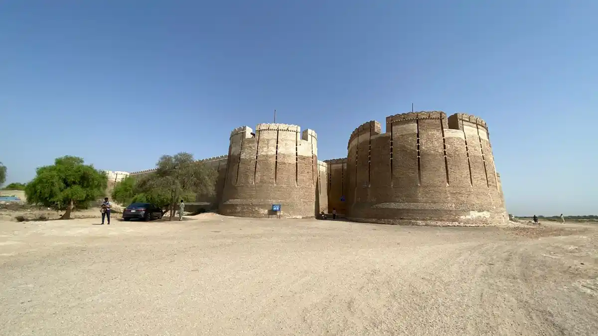
Standing upon the southern rim of the lower Indus valley where fertile cultivated plains yield to sweeping sand dunes, Naukot Fort remains one of the most remarkable historical fortifications in southern Pakistan. Located approximately sixty four kilometers south of Mirpur Khas and two hundred and eighty kilometers east of Karachi, this military stronghold occupies a prominent position in the Mithi taluka of the Tharparkar district. In regional literature and vernacular folklore, it is celebrated as the Gateway to the Thar Desert. The fort was established during the second decade of the nineteenth century by the ruling Balochi rulers of Sindh, functioning both as an imperial desert outpost and as an administrative hub for collecting agrarian revenue from nearby settlements.
In this article (38)
- Strategic Importance on the Desert Frontier
- The Gateway Location to the Thar Region
- Geographical Shield Against Rajput Incursions
- Historical Foundation Under the Talpur Dynasty
- Mir Karam Ali Khan and the Rise of Talpurs
- The Transition from Kalhora to Talpur Rule
- Architectural Anatomy of the Desert Fortress
- Masonry Methods and Rammed Earth Techniques
- Thermal Properties of Baked Mud Mortar Walls
- The Complex Layout of Bastions and Entrances
- The Massive Arched Portal and Angled Gateway
- Nine Semi Circular Watchtowers and Ramparts
- Internal Living Quarters Courtyard and Dungeons
- Subterranean Chambers and Powder Magazines
- Royal Court Courtyard and Garrison Barracks
- Military Logistics and Water Systems in Arid Lands
- Rainwater Harvesting in the Arid Landscape
- Grain Storage and Supply Chains for Soldiers
- Comparison with Other Fortresses Across Sindh
- Architectural Distinctions from Kot Diji Fort
- Structural Contrast with the Vast Ranikot Fort
- Environmental Vulnerability and Flood Damage
- Devastating Monsoonal Floods of Recent Years
- Salinity Rising Damp and Structural Cracking
- Archaeological Conservation and Restoration Work
- Interventions by the Antiquities Department
- Endowment Fund Trust Preservation Initiatives
- Visitor Guide for Travelling to Tharparkar
- Best Travel Seasons and Weather Considerations
- Reaching Naukot from Karachi and Hyderabad
- Cultural Etiquette and Desert Travel Protocols
- Frequently Asked Questions About the Fort
- When was the fort built and who was its founder?
- Why is it called the Gateway to the Thar Desert?
- What building materials were utilized in its construction?
- How many bastions does the fortification possess?
- Did the fortress experience damage during modern floods?
- Is the monument open to the general public?
Unlike earlier stone built citadels scattered throughout the northern reaches of Sindh, this defensive compound demonstrates a distinctive style of baked brick architecture assembled entirely without the use of structural timber or iron reinforcements. The sheer endurance of its tapered defensive ramparts, nine substantial bastions, and elevated cannon platforms offers a tangible record of late pre colonial military engineering. As a protected cultural monument under the provincial antiquities administration of Sindh, it provides invaluable insights into regional power dynamics, border security strategies, and hydraulic adaptations developed in harsh arid ecosystems.

Strategic Importance on the Desert Frontier
The geopolitical positioning of Naukot Fort was selected with great tactical foresight by the military planners of the eighteenth and nineteenth centuries. The fort sits at the precise frontier where the alluvial soil deposited by older distributaries of the Indus basin meets the vast Thar Desert. Understanding this geographical boundary is central to appreciating why such a major military investment was placed along what was otherwise considered an isolated frontier zone.
The Gateway Location to the Thar Region
The settlement of Naukot, whose name literally translates to New Fort, served as a primary commercial and logistical transit station between the major agricultural centers of Sindh and the nomadic caravan pathways traversing Rajasthan. Merchant trains transporting grains, raw cotton, woven textiles, and rock salts frequently halted at this junction before braving the dry desert trails leading east toward Umerkot, Islamkot, and Nagarparkar. By constructing a secure garrison directly beside this travel corridor, the rulers established an authoritative presence over regional trade. Travellers and trade convoys relied on the military post for protection against desert brigands who routinely raided unescorted caravans.
Furthermore, the fort served as an essential observation post over the pastoral communities residing across the Thar expanse. The seasonal movement of livestock, particularly indigenous breeds of cattle, camels, and goats, created economic interdependencies that required administrative regulation. Controlling this gateway allowed the central administration in Hyderabad to project state authority far beyond the lush banks of the Indus, cementing political stability across peripheral tribal regions.
Geographical Shield Against Rajput Incursions
During the late eighteenth and early nineteenth centuries, the southeastern borders of Sindh were vulnerable to armed cavalry sorties originating from neighboring princely states in Rajasthan, particularly Jodhpur and Jaisalmer. These cross border tensions stemmed from disputed territorial claims, rivalries over pasture lands, and shifting allegiances among border chieftains. To protect local Sindhi cultivators and safeguard southern granaries, a permanent military presence was indispensable along the edge of the dunes.
The fort operated as a robust forward defensive barrier designed to halt encroaching troops before they could advance inward toward the prosperous towns of the Indus delta. Its elevated lookout positions afforded sentries unobstructed views across miles of surrounding scrubland, preventing hostile regiments from organizing surprise encampments. In times of armed hostilities, rapid communication through relay riders and signaling fires linked this desert post directly with provincial garrisons stationed across southern Sindh.

Historical Foundation Under the Talpur Dynasty
The construction of this desert citadel is closely tied to the ascension of the Talpur Mirs, who governed Sindh following the overthrow of the Kalhora dynasty in 1783. The Talpurs belonged to a prominent Baloch tribal confederacy that had migrated into the Indus river valley generations earlier. Under their collective governance model, Sindh was organized into administrative divisions ruled by distinct branches of the dynasty, notably based in Hyderabad, Khairpur, and Mirpur Khas.
Mir Karam Ali Khan and the Rise of Talpurs
Historical chronicles confirm that Mir Karam Ali Khan Talpur commissioned the construction of the fort around the year 1814 of the common era. Mir Karam Ali Khan was one of the esteemed rulers belonging to the Char Yar alliance, a ruling quadrumvirate of brothers who shared supreme governing authority over lower Sindh from the royal court of Hyderabad. He was celebrated not only for his diplomatic acumen and military leadership, but also for his deep patronage of Persian literature, calligraphy, and regional architecture.
Recognizing the strategic vulnerabilities of the southeastern border, Mir Karam Ali directed imperial architects to construct a durable base capable of housing artillery units, cavalry detachments, and supply stores. The strategic design implemented at this site reflected the Talpur approach to governance. Rather than governing solely through punitive campaigns, the Mirs preferred establishing permanent fortified centers that supported regional agriculture, stabilized taxation, and provided safe refuge for local populations during regional skirmishes.
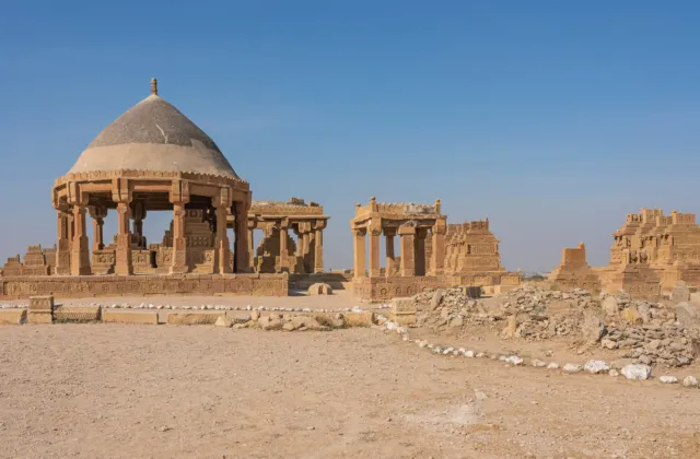
For readers interested in learning about the artistic and tribal monuments developed across lower Sindh during the same historical period, our detailed study on the Chaukhandi Tombs sandstone carvings provides comprehensive historical context on regional funerary craftsmanship.
The Transition from Kalhora to Talpur Rule
The rise of the Talpur dynasty represented a significant transformation in the political landscape of Sindh. The preceding Kalhora period, while characterized by the development of monumental canal irrigation systems, had suffered from severe internal factionalism and recurrent foreign invasions. When the Talpurs assumed control, they prioritized domestic stability and the consolidation of rural territories. Historical records indicate that while the eighty years of Kalhora administration witnessed dozens of internal rebellions, the six decades of Talpur rule experienced remarkably few uprisings.
Fortresses such as the one at Naukot formed the cornerstone of this defensive stability. They allowed the Mirs to maintain order with modest permanent garrisons while ensuring equitable water rights and agrarian revenue collection. The fortification remained under active Talpur military control until 1843, when British military forces led by Charles James Napier defeated the Mirs at the battles of Miani and Dubbo, ultimately bringing an end to sovereign Talpur rule across the province.

Architectural Anatomy of the Desert Fortress
The physical composition of the fortress reveals a masterclass in vernacular military design, precisely configured to withstand intense desert heat, dry winds, and enemy bombardment. In plan, the defensive perimeter is roughly quadrangular, presenting an imposing silhouette that emerges sharply from the desert floor without modern surrounding developments.
Masonry Methods and Rammed Earth Techniques
The primary perimeter of the citadel encompasses an enclosed area measuring approximately one hundred and thirteen meters in length by ninety eight meters in breadth. What distinguishes this construction from contemporary hill forts is its complete reliance on baked clay bricks laid in dense mud mortar. Historical surveys confirm that neither structural iron rods nor large timber crossbeams were utilized within the main fortification walls. The availability of fine alluvial clay along desert washes allowed local master masons to fire millions of dense, durable bricks in kilns constructed adjacent to the building site.
Beneath the hard brick skin of the ramparts lies a core constructed largely of tightly compacted rammed earth. This dual technique combined the durability of fired ceramic materials with the shock absorbing qualities of compressed soil. When struck by conventional artillery cannonballs of the era, the rammed earth core absorbed ballistic impacts without shattering, preventing the catastrophic wall collapses that often plagued rigid stone structures under heavy bombardment.
Thermal Properties of Baked Mud Mortar Walls
The environmental realities of the Thar Desert, where summer daytime temperatures frequently exceed forty degrees centigrade, demanded specialized construction methods. The thick brick masonry, bound by thick layers of local mud mortar, provided exceptional thermal insulation. During extreme daylight heat, the massive density of the ramparts retarded heat transfer into the interior chambers. At night, as desert temperatures dropped rapidly, the accumulated warmth radiated slowly outward, maintaining stable interior temperatures for stationed soldiers.
The exterior surface of the curtain walls was designed with a noticeable upward batter, meaning the walls taper inward as they rise from their wide base toward the upper battlements. This tapered cross section served a dual mechanical purpose. It significantly lowered the center of gravity of the towering structures, granting them higher resistance to ground shifting, while simultaneously presenting an angled exterior surface that caused incoming projectile fire to ricochet rather than hit perpendicularly.

The Complex Layout of Bastions and Entrances
Military fortifications in late medieval and early modern South Asia relied heavily on indirect, highly fortified entrance ways designed to trap and neutralize assault forces. The spatial organization of the entry gate at this Thar citadel exemplifies the sophisticated defensive doctrines developed across regional fortifications.
The Massive Arched Portal and Angled Gateway
The primary access to the fortress is situated on its southeastern perimeter, where visitors approach an imposing arched portal rising approximately seven meters in height and spanning four meters in breadth. This entrance does not offer direct, linear access into the interior compound. Instead, the approach forces an entering force to navigate a narrow, sharply bent causeway situated between heavy defensive works.
On the southern perimeter, an attached quadrangular bastion structure measuring fifteen meters by thirteen meters houses an elaborate inner vestibule and reception hall. Any attacking detachment attempting to breach the outer wooden gates would immediately find itself confined inside a narrow, bent passage under direct fire from elevated parapets above. This dogleg gateway configuration completely prevented approaching forces from employing heavy battering rams or directing coordinated cavalry charges directly into the courtyard.
Nine Semi Circular Watchtowers and Ramparts
The perimeter curtain walls are reinforced by a network of nine semi circular bastions positioned strategically around the four sides of the complex. Four massive bastions anchor the corners of the compound, while two heavy circular towers flank and protect the primary entrance gate. The remaining three bastions are positioned at the midpoints of the northern, western, and southern curtain walls, ensuring that no section of the perimeter remains blind to defensive fire.
The largest bastion, situated adjacent to the primary gateway, rises over nine meters in vertical height and possesses an expansive base with a diameter of roughly forty two meters. The top of the perimeter ramparts carries a four meter wide continuous walkway, or chemin de ronde, protected by brick parapets pierced with narrow musket loops and drainage outlets. Two sets of wide burnt brick staircases built into the interior face of the walls allowed rapid deployment of garrison troops and artillery crews from the central courtyard directly up to the battlements during defensive alerts.

Internal Living Quarters Courtyard and Dungeons
Beyond the formidable defensive shell, the interior of the fortress is organized around a spacious open courtyard that once bustled with domestic, administrative, and military activities. While many non load bearing partition walls have succumbed to weathering over two centuries, the archaeological ground plan clearly demarcates functional zones.
Subterranean Chambers and Powder Magazines
Among the most intriguing surviving components within the enclosure is a set of low set, vaulted brick rooms historically identified as the barood khana, or royal gunpowder magazine. These chambers were partially recessed below the courtyard surface and enclosed within extremely thick vaulted brick ceilings. Siting the ammunition magazine subterraneanly kept volatile black powder dry, shielded it from intense summer heat, and protected it from stray sparks or flaming projectile fire during combat.
Adjoining these chambers are several small, windowless cells that served as temporary lockups and disciplinary detention quarters. Regional oral histories collected by the Directorate General of Antiquities Government of Sindh record that these secure rooms were utilized by local administrators to hold captured raiders, recalcitrant feudal lords, and tax defaulters awaiting formal adjudication by the provincial magistrate.
Royal Court Courtyard and Garrison Barracks
The wide interior plaza accommodated the everyday needs of a self sufficient desert garrison. Remnants of brick foundations reveal the layout of regular soldiers barracks, which were arranged along the inner curtain walls to maximize open space in the central court. These quarters provided communal living spaces, cooking hearths, and weapon racks for the foot soldiers and mounted horsemen permanently stationed at the post.
Toward the northern section of the compound stood the residential suites and private audience chambers reserved for visiting Talpur Mirs and imperial tax collectors. Although designed primarily for defensive functionality, historical accounts mention that these royal pavilions were originally plastered with fine shell lime mortar, adorned with colorful fresco borders, and furnished with embroidered Sindhi floor coverings during seasonal visits by the court of Hyderabad.

Military Logistics and Water Systems in Arid Lands
Operating a functional military garrison in an arid territory requires extraordinary logistical preparation. Without reliable access to clean water and protected food supplies, even the most formidable fortress can quickly be starved into submission. The planners of this compound engineered sophisticated systems to sustain the defensive outpost throughout protracted sieges.
Rainwater Harvesting in the Arid Landscape
Water management was the paramount survival challenge in the Tharparkar desert. The architects incorporated an intelligent network of sloping surfaces, open drains, and underground masonry cisterns designed to capture every drop of seasonal precipitation falling across the extensive rooflines and interior courts. Rainwater collected during the brief summer monsoons was directed through sediment settling channels before pouring into deep, subterranean reservoirs constructed of impermeable brick masonry.
In addition to surface harvesting, deep water wells were excavated within the protective confines of the fort, penetrating the subterranean water table. These covered wells provided a dependable source of brackish to semi sweet groundwater during long periods of severe drought. By maintaining internal water security, the garrison eliminated the hazardous necessity of sending foraging parties beyond the protective walls during times of military siege.
Grain Storage and Supply Chains for Soldiers
The survival of the garrison depended equally on maintaining ample reserves of staple foodstuffs. Elevated granary chambers, constructed with raised brick plinths to prevent soil moisture and burrowing vermin from ruining supplies, were packed with millet, wheat, dried lentils, and clarified butter. The dry desert atmosphere naturally inhibited fungal rot and insect infestation, allowing grains to remain edible for extensive periods.
Secure supply routes linked the fortress directly to the fertile canal colonies bordering the Indus river near Tando Jan Muhammad and Digri. Pack trains composed of sturdy desert camels transported regular consignments of provisions, blacksmithing coal, saltpeter, and munitions from imperial workshops in Hyderabad, ensuring that the frontier outpost was fully equipped throughout the year.

Comparison with Other Fortresses Across Sindh
To fully grasp the architectural significance of this desert stronghold, it is instructive to compare its structural traits with other famous fortifications built across Sindh during the medieval and Talpur periods. Sindh features a diverse spectrum of military architecture, ranging from colossal stone mountain walls to compact desert outposts.
| Fortress Name | Primary Material | Key Architectural Purpose | Historical Era |
|---|---|---|---|
| Naukot Fort | Baked brick and mud mortar | Desert frontier post and trade gateway | Early nineteenth century |
| Kot Diji Fort | Kiln fired brick on stone hill | Princely citadel and royal armory | Late eighteenth century |
| Ranikot Fort | Sandstone and lime mortar | Vast mountain barrier wall | Ancient to Talpur reconstruction |
| Umerkot Fort | Mud and burnt brick | Desert transit and administrative base | Mughal and Talpur rebuild |
Architectural Distinctions from Kot Diji Fort
When examined alongside the famous citadel of Kot Diji in upper Sindh, striking architectural contrasts become immediately apparent. While Kot Diji is perched atop a steep natural limestone hill overlooking the Rohri ridge, the fortress at Naukot rests entirely upon flat desert terrain. Consequently, the builders of Kot Diji utilized the natural topography to create tiered, multi level defensive perimeters that forced attackers to advance uphill through three successive gates.
At Naukot, by contrast, the architects could not rely on natural slopes. They compensated for the flat terrain by creating an extraordinarily massive ground level entrance, exceptionally thick curtain walls, and nine expansive circular bastions that provided sweeping lines of crossfire. Kot Diji served as a majestic, multi tiered royal residence and regional capital for the Sohrabani branch of the Talpurs, whereas Naukot was built strictly as a functional, heavily garrisoned frontier fort.
Structural Contrast with the Vast Ranikot Fort
A comparison with the colossal walls of Ranikot, located in the Kirthar mountain range, illustrates the diversity of military engineering across Sindh. Ranikot, often cited as one of the largest fortresses in the world, spans an enormous perimeter of more than thirty kilometers, encompassing entire mountain ridges and river valleys within stone and lime walls. The colossal scale of Ranikot required millions of tons of quarried sandstone and an immense garrison to patrol its vast length.
In contrast, the fortress at Naukot is compact, concentrated, and practical. Its perimeter measures less than half a kilometer in total circumference, allowing a disciplined company of one hundred to two hundred soldiers to defend every bastion effectively. Rather than utilizing heavy dressed stone, which was entirely unavailable in the desert sands around Mithi, the masons of Naukot demonstrated masterly resourcefulness by relying exclusively on indigenous baked brick and local clay mortar.
Environmental Vulnerability and Flood Damage
Despite surviving more than two centuries of arid desert conditions, the architectural integrity of the fortress faces severe modern environmental threats. The fragile equilibrium that preserved mud mortar masonry for generations has been repeatedly destabilized by shifting global weather patterns, torrential monsoons, and soil chemistry degradation.
Devastating Monsoonal Floods of Recent Years
The most catastrophic structural threats in the modern era arose during the unprecendented monsoon downpours of 2011 and 2022. Historically, the Thar Desert received sparse seasonal rainfall, rarely exceeding a few inches annually. However, anomalous climate events brought torrential rains that inundated the low lying plains of southern Sindh, causing prolonged flash flooding across the districts of Mirpur Khas and Tharparkar.
During the 2011 monsoons, standing rainwater collected deep around the exterior foundations of the fort. Because the desert soils have limited drainage capacity, floodwaters remained stagnant against the brick ramparts for weeks. The moisture penetrated the mud mortar bindings, resulting in the softening of the interior rammed earth core and causing a catastrophic collapse of a forty foot section of the primary curtain wall. Similar catastrophic downpours in 2022 exacerbated water seepage, triggering structural fractures along several secondary bastions and washing away protective earthen coatings.
Salinity Rising Damp and Structural Cracking
Beyond direct rainfall, the insidious phenomenon of rising damp and soil salinity presents a persistent conservation challenge. The expansion of irrigation canals in nearby agricultural tracts has raised the subterranean water table throughout the surrounding lowlands. As capillary action draws mineral laden moisture upward through the porous baked bricks, water evaporates upon reaching the exterior surface, leaving behind crystallized salt deposits.
This process, known as subflorescence, exerts immense internal crystallization pressure within the microscopic pores of the fired clay. Over time, the outer face of the historic bricks crumbles into fine ceramic powder, a process that steadily hollows out the base of the massive bastions. Without continuous structural intervention, this progressive decay poses a severe hazard to the long term stability of the monuments.
Archaeological Conservation and Restoration Work
In response to rising environmental pressures, regional cultural organizations and governmental heritage departments have launched comprehensive conservation campaigns aimed at stabilizing the historical site and reversing past structural damage.
Interventions by the Antiquities Department
Following the devolution of heritage preservation under the Eighteenth Constitutional Amendment, management of the site was assumed by the provincial government of Sindh. The antiquities department undertook emergency salvage programs following both major flood crises, removing accumulated stagnant water from the interior courtyards and installing deep drainage conduits to prevent future pooling.
Conservation teams have prioritized the stabilization of fractured bastions using traditional materials. Crucially, modern restoration guidelines strictly prohibit the application of Portland cement, which traps internal moisture and accelerates the decay of historic brickwork. Instead, trained artisans utilize traditional kankar lime slaked on site, blended with fine river sand and organic additives, to repoint degraded brick seams in full accordance with international conservation standards established by the UNESCO World Heritage Centre.
Endowment Fund Trust Preservation Initiatives
Substantial stabilization work has also been directed by non governmental heritage organizations, most notably the Endowment Fund Trust for Preservation of the Heritage of Sindh. Between 2011 and 2014, the trust mobilized specialized engineering teams to execute a comprehensive restoration program across the compromised southern and western ramparts.
The conservation work involved clearing tons of collapsed debris, stabilizing the exposed rammed earth foundations, and reconstructing damaged masonry sections using custom made baked bricks matching the precise dimensions, clay composition, and density of the original nineteenth century materials. Continuing research documentation and topographic laser surveys conducted by these teams ensure that future preservation efforts will maintain absolute fidelity to the original architectural configuration.
Visitor Guide for Travelling to Tharparkar
Visiting this historic desert fortress offers heritage enthusiasts, historians, and photographers a deeply rewarding journey into Sindh’s frontier past. Proper preparation is essential to navigate the arid climate and ensure a culturally enriching trip.
Best Travel Seasons and Weather Considerations
The ideal window for travelling to the Tharparkar district extends from late November through February. During these winter months, daytime temperatures are pleasantly mild, ranging between twenty and twenty six degrees centigrade, while nighttime temperatures drop sharply into cool single digits. The low humidity and crisp desert air provide optimal conditions for walking around the ramparts and photographing the red brick architecture against vivid blue skies.
Conversely, the summer period from May through August brings punishing heat, with daily temperatures routinely climbing above forty two degrees centigrade. Direct sunlight on the unshaded ramparts can make walking hazardous for unprepared travellers. An alternative travel period is September, immediately following the summer rains, when the surrounding desert landscape undergoes a brief transformation into rolling green pastures populated by grazing herds and wandering peacocks.
Reaching Naukot from Karachi and Hyderabad
The fortress is conveniently accessible via modern paved highways connecting the major urban centers of Sindh with Tharparkar. Travellers departing from Karachi can follow the National Highway toward Hyderabad, before turning southeast along the Mirpur Khas route. From Mirpur Khas, a well surfaced secondary highway extends sixty four kilometers directly south to the town of Naukot, a journey requiring roughly four to five hours by private vehicle.
Alternatively, visitors travelling from Hyderabad can proceed through Tando Allahyar and Mirpur Khas, reaching the fortress in approximately three hours. Public coaches, air conditioned vans, and regional buses run regularly between Mirpur Khas and Mithi, stopping directly at the Naukot central bazaar, from which the fort entrance is located just over two kilometers away. Local motorized rickshaws and taxis provide inexpensive transfers directly to the monument gates.
Cultural Etiquette and Desert Travel Protocols
The communities inhabiting the Tharparkar region are renowned across Pakistan for their warm hospitality, deep rooted communal harmony, and vibrant folk traditions. Visitors are encouraged to observe standard cultural courtesies by dressing modestly, respecting religious sensibilities, and seeking permission before photographing local residents or pastoral encampments.
Because the monument does not feature commercial dining facilities or modern rest houses within the immediate perimeter, travellers should carry adequate supplies of clean drinking water, protective sun hats, sunglasses, and high traction walking shoes suitable for sandy soil and steep brick stairways. Local shops in Naukot bazaar offer traditional Sindhi snacks, tea, and seasonal fruits, while comprehensive hotel accommodations and guest house facilities are available in the nearby district headquarters of Mithi.
Frequently Asked Questions About the Fort
When was the fort built and who was its founder?
The fort was constructed in the year 1814 of the common era under the patronage of Mir Karam Ali Khan Talpur, one of the primary rulers of the Talpur dynasty of Sindh.
Why is it called the Gateway to the Thar Desert?
It earned this designation because of its strategic geographic location on the border between the irrigated plains of lower Sindh and the arid expanses of the Thar Desert, guarding the primary historic caravan and military route into the desert.
What building materials were utilized in its construction?
The fortress was constructed almost entirely using local kiln fired burnt clay bricks laid in thick mud mortar, with an interior core of compacted rammed earth. Remarkably, neither structural iron nor timber beams were used in building the exterior ramparts.
How many bastions does the fortification possess?
The compound is fortified by nine large semi circular bastions. These include four corner towers, two massive circular bastions defending the angled entrance gateway, and three mid wall towers positioned along the northern, western, and southern perimeters.
Did the fortress experience damage during modern floods?
Yes, unprecedented monsoonal rains and stagnant floodwaters caused severe structural damage in August 2011 and September 2022, resulting in partial wall collapses and moisture seepage that required major interventions by provincial conservation organizations.
Is the monument open to the general public?
The fort is open year round to public visitors, researchers, and tourists under the administration of the provincial government of Sindh. Entry tickets are nominal, and the grounds can be toured on foot throughout daylight hours.


Leave a Comment